Need assistance? Call us on
01722 717 132
Number of items in basket: 0
|
 View Basket
- Home
-
Family Tree Maps

1:2,500 Family Tree Maps

1:10,000 Family Tree Maps

1:50,000 Family Tree Maps
-
British Maps
1:2,500 mapping
1:10,000 mapping
1:50,000 mapping
- Explore
Keys and Legends
Over the years the Keys and Legends (the two terms are interchangeable) shown on the various Ordnance Survey mapping series have changed as the features in the landscape have evolved. Over time the most important features on a map reflected the spirit of the day.
One inch to the mile (1:63,360)
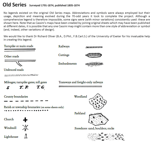
Old Series
These maps were the result of the first ever national survey of England & Wales. From the late 1790s until 1874, a small army of surveyors covered every corner of the what was still an almost entirely rural country. Their work provided a stunning portrait of the landscape, with every farm, track, copse and hamlet recorded. Many of these features would have been unchanged for centuries, reminders of ancient patterns of settlement dating back to Saxon times. The maps elegantly capture the age of the canal, the coaching inn and the horse-drawn cart: the final decades of an agrarian society that was soon to be over-run by new transport links, rapid population growth and urban expansion.
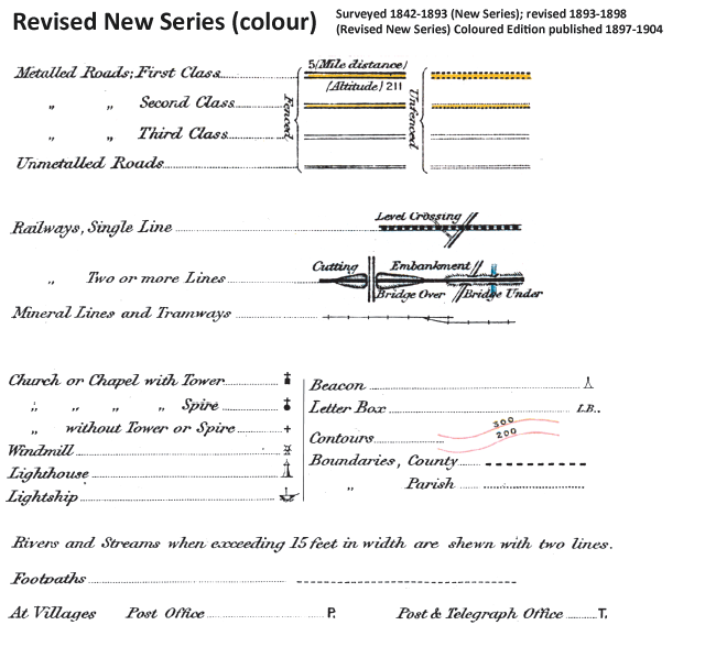
Revised New Series
After the Old Series came the Revised New Series. By the late 1890s, the Ordnance Survey had produced two complete series of maps of England & Wales but the increasingly rapid pace of change and development meant that revising them was now a never-ending task. The main cause of this change was the growth of the railways. From being little more than a good idea in 1830, the network covered over 18,000 miles by the end of the century, enabling the spread of goods, people and ideas and changing the character of every place it touched. The late 19th-century was without doubt the age of the railway, and the Revised New Series is the definitive record of its glory years.
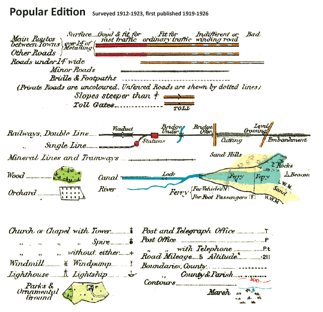
Popular Edition
The original Ordnance Survey Popular Edition series was conceived before, but published just after, the First World War. This was the first of Ordnance Survey’s series to be conceived from the outset as a mass-market product, and the first to be produced in full colour.
If the railways were the transport revolution of the 19th century, the motor car was certainly that of the 20th. The new Popular Edition had to reflect this. For the first time the gradations of the road network were described, with each route being coloured according to its suitability or otherwise for motor traffic. Twenty times more vehicles were registered in the UK in 1929 compared to 20 years earlier, and many of those who could not afford (or did not dare) to use a car cycled instead. Increased leisure time and rising prosperity fuelled a demand for travel. As a result, accurate, relevant and up to date maps were needed.
New Popular Edition
These maps reveal the reality of the outwards spread of urban populations with great clarity. For the first time, the areas covered by the series shows the build-up of towns and cities and their rapid expansion into the countryside. The railways, though now at their maximum extent, are represented on this map far less prominently than are the roads, reflecting their reduced importance. The New Popular Edition is a record of a battered Britain at the end of a global war and nearing the end of a period of global imperialism. 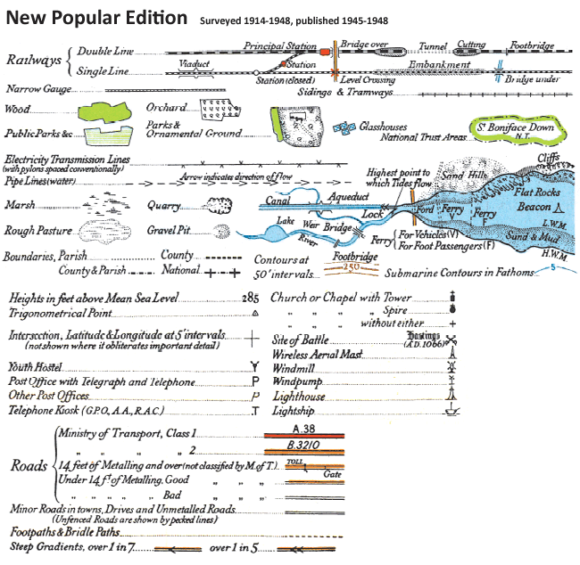
Present Day Landranger
The current Ordnance Survey 1:50,000 mapping (represented, in most people’s minds, by the Landranger® series) is the culmination of over 200 years of painstaking and continuous surveys of the British landscape. Known as the 1:50,000 First Series when it was first published between 1974 and 1976, the printed form acquired the ‘Landranger®’ name in 1979. These maps have stood the test of time and remain the definitive survey of the country. Features as diverse as shopping centres and disused railway lines, car parks and stone monuments, rock screes and picnic sites are all included, indicated by an increasing range of symbols and abbreviations.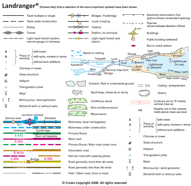
Six Inch to the Mile County Series
The origins of the six inch to the mile (1:10,560) maps date back to 1824 when this scale was adopted for a survey of Ireland. By 1840 it had been decided to extend the project to Great Britain. Work began in Lancashire and Yorkshire in 1841 and in Scotland in 1843 with the first sheet appearing in 1846. It was not until 1890 that maps covering the whole country had been published, a family of maps that later became known as the County Series. By that time revisions to the earlier sheets were underway, a rolling process that continued until the last County Series sheets were superseded by the 1:10,000 National Grid Edition in the 1980s. Each sheet appeared in up to six editions, displaying various evolutions of detail, format and reproduction technology.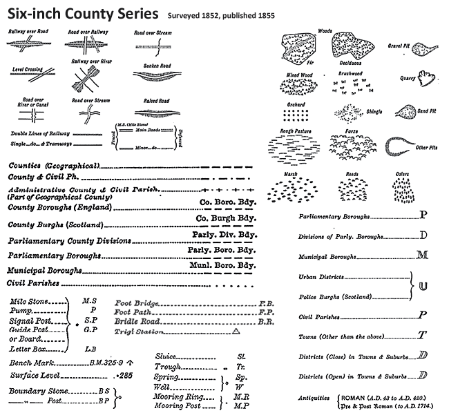
1:25,000 County Series
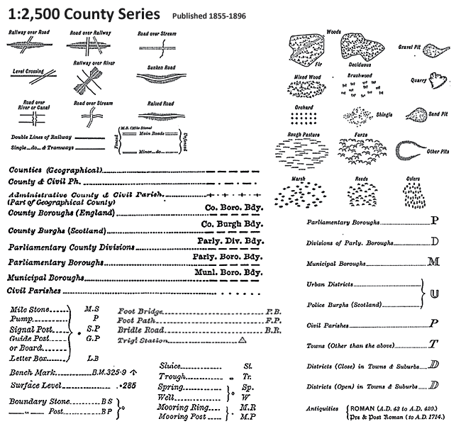
The first maps at 1:2,500 (roughly 25 inches to the mile, or roughly one square inch to one acre) were Published in 1855 with coverage of the cultivated parts of Great Britain being completed in 1896. By then, a thorough revision had already started; indeed, the process of updating the information and publishing the results in a variety of formats has continued until the present day.
Almost every man-made feature of any significance is displayed on these maps which thus form a definitive record of the changing landscape of Britain since the middle of the 19th century. They are of considerable importance to historians (although this would have been inconceivable to their creators). The detail zooms in to house-level and offers a wealth of additional information concerning land usage, communications and boundaries. For genealogists they are of particular use and interest. Not only do they offer countless research clues which no other source can match but they also reveal every nuance of the landscape inhabited by past generations, so helping to explain many of the preoccupations and limitations that ruled their lives.
Ancestry-maps has a collection of Ordnance Survey maps dating back to 1805, or for earlier maps why not visit our sister site Cassinimaps for our collection of 16th, 17th and 18th maps from Cassini's British Library collection.