Need assistance? Call us on
01722 717 132
Number of items in basket: 0
|
 View Basket
- Home
-
Family Tree Maps

1:2,500 Family Tree Maps

1:10,000 Family Tree Maps

1:50,000 Family Tree Maps
-
British Maps
1:2,500 mapping
1:10,000 mapping
1:50,000 mapping
- Explore
Genealogy and Maps
Many people today are interested in genealogy to understand not just where and when people lived, but also their lifestyles, surroundings and motivations. This often requires knowledge of old political boundaries, migration trends and historical social conditions. One important way to understand how one's ancestors fit into the landscapes of the past is to place them in space and time by using historical mapping. 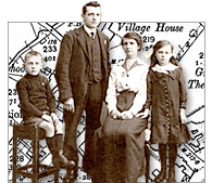
"My Mother’s grandmother came from Woolbeding, a tiny settlement near Midhurst. I found your map very useful when I went to visit the area because I could trace the original roads unobscured by modern developments. It was great to see the house where my great-grandmother’s twin sister was a dairy maid in 1871 and the tiny church next door still candlelit where they were baptised." Miss Driscoll, Manchester
Genealogical research is a complex process that uses historical records to answer questions about ones ancestors, the time they lived in, the work they undertook and their surroundings. Reliable conclusions are based on quality sources and historical maps have an important part to play in discovering where and how your ancestors lived.
From the beginnings of Britain's industrial past to the more sedate life of a victorian country village more detailed can help to put the lives of your ancestors into context. The interest In old maps is constantly growing as more maps become available and the ability to see more and more detail allows the researcher to view ever increasing details of the past.
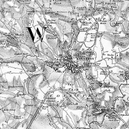
For example - In the last 200 years Coventry has grown in population from 21,853 in 1801 to 310,500 in 2010. Many of the old outlying towns and villages have been absorbed into the conurbation we see today and the only way of understanding the landscape they used to live in is to view the maps of the time.
 |
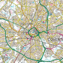 |
| Old Series 1831 | Present Day |
"Old maps of the sort published by Cassini are an excellent introduction to local history throughout the United Kingdom because they focus the user’s attention on the sort of unexpected questions that act as starting points for research. “Well, I never knew that there was a house in that location 200 years ago”. “I never realised that xxxx Road followed a different course 150 years ago . . . why?”. Of course, detailed local histories will probably contain the answers to some of these questions – but they hardly ever force them on you as vividly– and attractively – as old maps. And, in some cases, you will find yourself asking questions that even the standard histories do not answer. So, before consulting those published histories, look at the maps!" Peter Barber MA, FSA, FRHistS Head of Map Collections, British Library
From the beginnings of Britain's industrial past to the more sedate life of a victorian country village detailed maps are now available to put the lives of your ancestors into context. The interest In old maps is constantly growing as more maps become available and the ability to see more and more detail allows the researcher to view ever increasing details of the past.
Ancestry-maps has a collection of Ordnance Survey maps dating back to 1805, or for earlier maps why not visit our sister site Cassinimaps for our collection of 16th, 17th and 18th maps from Cassini's British Library collection.