Need assistance? Call us on
01722 717 132
Number of items in basket: 0
|
 View Basket
- Home
-
Family Tree Maps

1:2,500 Family Tree Maps

1:10,000 Family Tree Maps

1:50,000 Family Tree Maps
-
British Maps
1:2,500 mapping
1:10,000 mapping
1:50,000 mapping
- Explore
How Heath Row became Heathrow
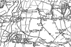
This brief overview looks at the history of Heathrow and the area on which it was built with the aid of four historical Ordnance Survey maps. In each case the present-day airport (pale pink) and the proposed expansion (pink) have been superimposed. 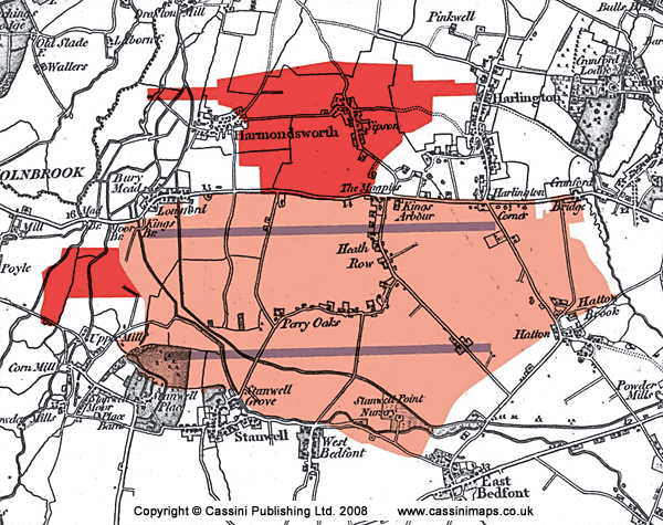 Extract taken from Old Series 176 - West London (1805 - 1822)
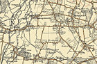
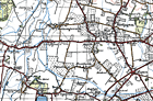
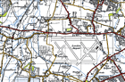
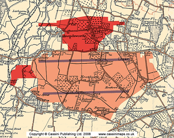 Extract taken from Revised New Series 176 - West London (1897-1909)This map was created from Ordnance Survey's Revised New Series (in colour) maps which were first published between 1896 and 1909. They have all been carefully scanned, digitally re-projected and enlarged to match the present-day Ordnance Survey Landranger® series Heathrow's aviation history goes back to the First World War when the site was used as a military airfield, although little evidence remained by the time of the Popular Edition map of 1920. In this year the airport was closed due to various logistical reasons including bad communication, the bumpy nature of the ground, its tendency to become boggy and muddy in winter and its frequent covering of mist. As the map showing the current expanse of the airport shows, these problems have since been overcome. By the 1930s the airfield had become known as the Great Western Aerodrome, privately owned by Fairey Aviation, and was used for aircraft assembly and testing. It had become clear that civil aviation would increase (though few would have predicted by how much), and the government began to make provision for the capital’s air services. The plan was to expand the two existing aerodromes at Croydon and at Heston, to the east of modern-day Heathrow, and to add two new ones, at Fairlop in Essex and Lullingstone in Kent. Work was under way on all these projects when war was declared in September 1939. 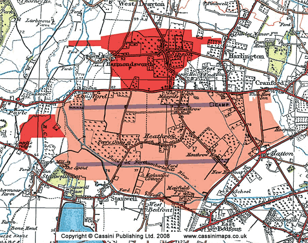 Extract taken from Popular Edition 176 - West London (1920)It can be seen from the three preceding maps that the area of Heath Row experienced various changes during the 19th and early 20th centuries. Although most of the settlements expanded only slowly, the character of the area was starting to be reflect the growth of nearby London: the increased cultivation, the railways, the growth of East Bedfont (and the creation of its school), the emergence of Southville and the construction of the Staines Reservoir all show the area’s increased importance as a supplier of goods, services and labour to the vast metropolis that was expanding towards it at an alarming rate. From late 1942, there was increasing demand from the Air Ministry for a base for the new long-range heavy troop-carrying planes, existing facilities in the south of England being inadequate. After some debate, a slightly boggy area of market-garden farms to the west of Heston Aerodrome was chosen as the site of a wholly new airfield. Construction work began in May 1944 on land originally acquired from the vicar of Harmondsworth. Although the location was ideal, the terrain was not. 100 million gallons of water had to be pumped out of the ponds and the 14 miles of pipes were needed to drain rainwater into a nearby gravel pit. Another task was the clearance and demolition of the hamlet of Heath Row: few other places have become so posthumously famous. At the time, the Air Ministry’s case must have seemed unanswerable, but doubts exist as to whether there was ever any intention to use Heathrow for military purposes. The fortunes of war were shifting in the Allies’ favour, so making large-scale troop movements by air less likely; whilst the argument for a large new civil aerodrome was clear to those who were considering how post-war Britain might be shaped. Due largely to wartime innovations, aircraft were now far bigger. Commercial air travel before the war was still a novelty – when Prime Minister Neville Chamberlain left Heston Aerodrome for the first of his ill-fated meetings with Hitler in 1938 it was the first time he had been in a plane, which caused little comment at the time – but demand seemed likely to increase substantially in the future. The 1930s plan of four small airports around the capital was now inadequate. Instead, the contemporary logic ran, one larger hub was needed which could be purpose-built for the new planes and would be capable of expansion in the future. The main problem was that any civil project on this scale would have led to protracted planning enquiries and divisive financial wrangles within Whitehall. Using wartime powers to requisition the land offered a far more certain outcome. The then Parliamentary Under-Secretary Harold Balfour later admitted that he had misled the cabinet on this point in order to expedite the process. Were military use the only requirement, many existing RAF bases could have been converted with far less time and effort. Whatever the real motives, Heathrow was allowed to slip into being almost unnoticed, in marked contrast to the glare of publicity which attended many of its later developments. Heathrow would not have been the first project by a national government promoted under the guise of military exigency, and is unlikely to be the last. In the event this potential conflict of interests and purpose never materialised, for construction was still not complete by the end of the war. The military origins of the project were quietly forgotten and work continued on building what was now unambiguously a civilian airport. This was officially opened in May 1946 with a flight to Buenos Aires via Lisbon, the departing passengers enjoying terminal facilities that consisted of little more than a large tent. At the time, Heathrow’s managers stated, with rare prescience, that it would eventually become the largest airport in the world. The next few years did little to justify this optimism. Numerous problems were encountered with the construction of terminal buildings and the second runway, not helped by post-war restrictions in obtaining suitable materials. As late as mid 1948, Northolt (which Heathrow was intended to supersede) was actually handling more travellers. Yet all these problems were eventually overcome. In 1953, Heathrow handled a million passengers (about the number of people that used it every five days in 2006), and this had increased to 20 million by 1973. Now it is comfortably the world’s busiest international airport with over 61 million international travellers in 2006 (more than the population of the UK) and is the daily workplace of around 75,000 people (about the population of Basingstoke). Indeed, it is the largest single-site employer in the country. Other statistics are more bizarre, though perhaps in their own way no less revealing: 10% of the UK’s perfume sales are made at the airport, for instance.How long all this growth can continue for is anyone’s guess. The advocates of the third runway and the sixth terminal suggest that expansion is essential, and that the economic benefits to the UK’s economy will be in the region of £7 billion a year. Others, including environmentalists and local residents, question whether the financial benefits (if realised) would outweigh the negative factors of disruption, pollution and noise. Heathrow seems set to be at the heart of the debates about the future of transport, development, environmental issues and government policy for many years to come. Expect more enquiries, more protests and more statistics: a blaze of publicity, in short, in contrast to the furtive way in which the airport came into being sixty-odd years ago. 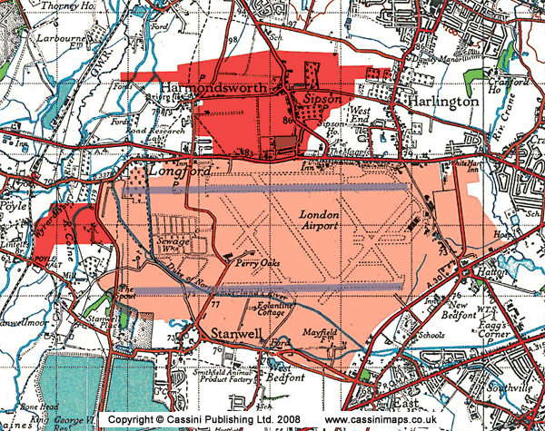 Extract taken from New Popular Edition (1945) |
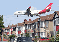 In January 2009, the Government gave the go-ahead for a third runway and a sixth terminal at Heathrow, already by some distance the world's busiest international airport. This will increase the annual number of flights from 480,000 to 700,000 and will require the demolition of 700 homes in the borough of Hillingdon, including all of the ancient village of Sipson and parts of Harmondsworth and Harlington.
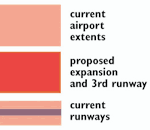
Ancestry-maps has a collection of Ordnance Survey maps dating back to 1805, or for earlier maps why not visit our sister site Cassinimaps for our collection of 16th, 17th and 18th maps from Cassini's British Library collection.