Need assistance? Call us on
01722 717 132
Number of items in basket: 0
|
 View Basket
- Home
-
Family Tree Maps

1:2,500 Family Tree Maps

1:10,000 Family Tree Maps

1:50,000 Family Tree Maps
-
British Maps
1:2,500 mapping
1:10,000 mapping
1:50,000 mapping
- Explore
Old Maps and Genealogy - a beginners guide.
Family History
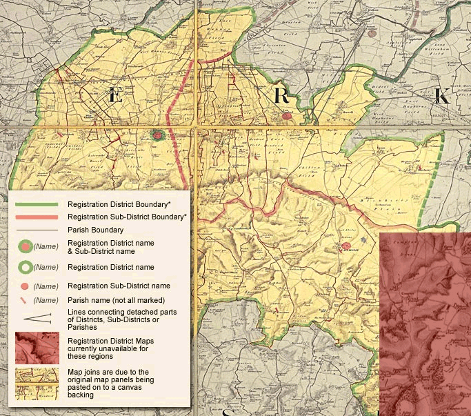
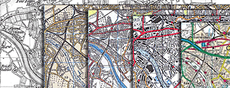
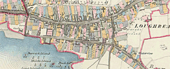
"In some cases, you will find yourself asking questions that even the standard histories do not answer. So, before consulting those published histories, look at the maps!" Peter Barber MA, FSA, FRHistS Head of Map Collections, British LibraryTracing your family history is a growing area with genealogy now reported to be the second most popular hobby in the USA. There are an increasing number of web sites on the internet that provide access to historical records to aid your research, including Ancestry, Find My Past, Genes Reunited, Origins, FamilySearch, World Vital Records, My Family Tree, the list goes on, but there are times when the records themselves don't tell the whole story. Sometimes looking at distances 'as the crow flies' can be deceptive. It may be that there was a major road that made it easier to travel ten miles to one church rather than five miles over rough terrain to another. The same can happen with hilly or mountainous terrain - why climb a steep hill to get to a destination rather than going a few extra miles on a flatter faster path. By viewing the maps you can often get an insight into where, and why, ecclesiastical and civil records can be found. It's not just for the sake of local convenience where maps can help. Take the instance of members of a family suddenly moving from somewhere like rural Norfolk to the a Northern town in the early 1800s. Looking at the historical maps may show how a sudden increase in factories, mills and new industries in general may have led to a demand for labour that the local population couldn't support and the promise of jobs became the lure that attracted our ancestors to pack up their possessions and move to a new part of the country. Census and Parish RecordsMany records such as census and parish records hold geographical data that actually doesn't mean anything unless you can see the location on a map.Not only are the old maps the only way of seeing and understanding these administrative areas, but often it is the maps themselves that have been used to define where the boundaries were drawn. The UK has a bewildering array of administrative boundaries including: Country boundaries, County boundaries, Parliamentary constituencies, Metropolitan districts, Unitary Authorities, Registration Districts, Registration Sub-districts, Enumeration Districts, Ancient Parishes, Ecclesiastical Parishes, Civil Parishes, Poor law unions, Hundreds, etc. There are many more historical and modern day boundaries to contend with and what makes life even harder for the researcher, without the contemporary maps, is that all of these boundaries change over time. Some maps have been re-purposed to try and define some of these boundaries for specific purposes, like the Registration District Maps of 1871 (held by The National Archive - RG18). Hand drawn on top of Ordnance Survey Old Series Maps, every Registration District, Sub-Registration District and Parish were shown, although not always easily readable, but once the areas are identified larger scale (more detailed) maps can be used to view town and street level detail. God is in the detail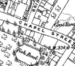 With the decimation wrought by World Wars and town planners the locations mentioned in historical records may no longer exist. Whole streets have disappeared, many have had their names changed, even the spelling of town and village names have gone through the distortions of time and may not be found using today's search tools. With the decimation wrought by World Wars and town planners the locations mentioned in historical records may no longer exist. Whole streets have disappeared, many have had their names changed, even the spelling of town and village names have gone through the distortions of time and may not be found using today's search tools. Map Scales The smallest scale maps on this site are the 1:50,000 maps, digitally enhanced from the original One Inch to the Mile Ordnance Survey maps. The maps have been combined, re-projected and enlarged to match the scale and coverage of the present-day Ordnance Survey Landrangers®, so making direct comparison between the past and the present easy and accurate. Once you've identified the location you can drill down to the 1:10,000 maps to identify the layout of the towns and villages before zooming in to the 1:2,500 mapping to see the fine detail of your chosen location - street names, features, public buildings, train stations, canal docks, etc. in fact, short of the actual house numbers, everything you would need to identify where your ancestors came from. Out in the field Even if you're someone who prefers to go to the source for your records, for example the parish church or local records office, don't forget to take a historical map with you as the area you visit is likely to have changed, in some cases drastically, and without the map as a reference you may never be able to identify the exact location as mentioned in those early records. |
With the interest in programmes like Who Do You Think You Are and Time Team, interest in family and local history has never been higher. |
|||||||||||||||||||||||||||
© 2015 Cassini Publishing Ltd.